Net of Natural
Trails

Stage 10: Valverde de Júcar - Buenache de Alarcón
Description
Entering the Manchuela region of Cuenca.
After crossing one of the branches of the Alarcón reservoir, this short stage of the Júcar Nature Trail runs almost exclusively along rural roads between fields of crops, approaching the reservoir again, but without returning to its banks. This stage is the gateway to the Júcar Nature Trail in the region of La Manchuela Conquense.
WARNING: Part of this stage may be flooded depending on the level of the Alarcón reservoir. It is advisable to check the conditions of the road before setting off.

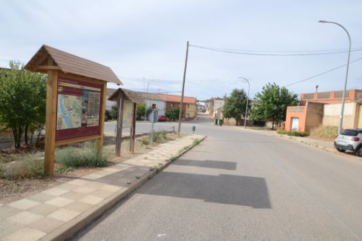
The tenth stage of the Nature Trail begins in Valverde de Júcar, on Avenida de Madrid Valencia. Continue down this avenue (be careful at the crossroads), which winds around several bends until you reach, one of the tails of the Alarcón reservoir after passing a school. Specifically, the one formed by the mouth of the rivers Albaladejo and Gritos.

When the waters of the reservoir reach a certain level, part of this section may be impassable, requiring a detour around the tail of the reservoir to get back on the road to Hontecillas via rural tracks.
The village of Hontecillas is only briefly skirted, as the road turns ninety degrees just as it reaches the justice roll that is preserved on the outskirts of the village. The asphalt track turns into a dirt track just past a shed, heading south-west. The landscape of dry crops is only interrupted by the occasional tree crop or the accompanying vegetation when crossing a stream.

Ignoring all the crossroads and continuing straight ahead, the track turns southeast after 3 km. After 4 km of walking through the same environment as in the previous section (we can find the crossing of a stream or the pass next to a water reservoir) we reach the CM-2100 road.
Crossing the road with extreme caution, as there is a stretch between two bends, you reach Buenache de Alarcón along a path that soon becomes one of the streets of the village. This stage ends at the junction of Calle San Miguel, Calle Agua and Calle Isabel I de Castilla, although it is worth walking a few more metres and visiting the unique church of San Pedro Apostol, declare Heritage of Cultural Interest in 2011, or the Town Hall square..
Enlaces de interés
Puntos de interés
Culture
Hydrography
Municipality
Hostel
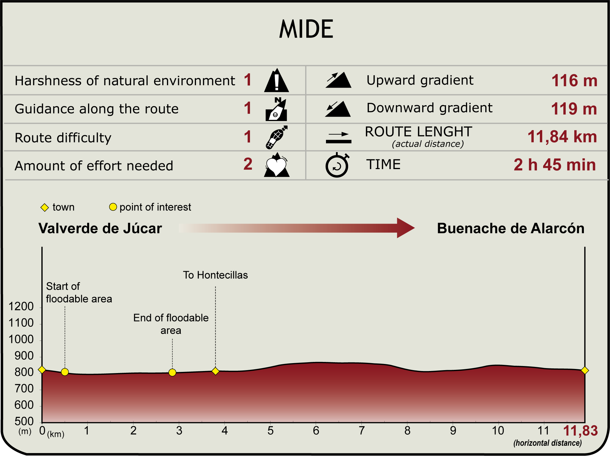
Profile

MIDE (Method for the Information of Excursions)
Highlights
Further information
Hontecillas
Hontecillas is a municipality in the region of La Manchuela, on the banks of the river Júcar, 51 kilometres from the provincial capital.
The town of Hontecillas, formerly known as Fuentecillas, due to the large number of fountains in the municipality, has its origins in prehistoric times, as can be seen from the remains of various prehistoric sites and settlements found in the area. But it was not until the repopulation of the province of Cuenca by Christian troops, and the conquest of Alarcón in 1184 under Alfonso VIII that the site was established. Later, in the 14th century, Hontecillas would become part of the Lordship of Alarcón, the municipality being represented by Don Juan Manuel, nephew of Alfonso X.
The municipality boasts some interesting architecture, including the Parish Church of Nuestra Señora la Virgen del Romeral. This is a church of Romanesque origin that has undergone various modifications, including Renaissance additions and enlargements.
Made of masonry, the only surviving remains are the central nave, the apse and the wall of the Romanesque belfry, which was later modified by adding a Renaissance look, so that it now consists of two sections crowned with a triangular top, balls and pinnacles.
You can visit the shrine of La Concepción, a small temple located on Calle de San Pedro, which has recently been restored; the Parque del Lavadero, where you can find the Roman Fountain of Hontecillas, the Fuente del Pilar and the Rollo Jurisdiccional located at the entrance to the town and the Plaza del Ayuntamiento (Town Hall Square).
As for local festivals, they are celebrated in honour of the Virgen del Romeral during the second week of August, with the main procession on the 15th.
Valverde de Júcar
The municipality of Valverde de Júcar in Cuenca is located in a border enclave between the regions of Manchuela, Serranía Media and La Mancha Alta.
A number of different vestiges of Celtiberian settlements and funerary constructions have also been found in the area. There are also later remains of various Hispano-Roman civil works such as the hill of San Marcos, the possible location of an ancient Roman fort with a watchtower, and the Cano Bridge.
But Valverde de Júcar's golden age dates back to the Middle Ages, with the repopulation and the capture of Alarcón by Christian troops in 1184. The town belonged to the Council of Alarcón until 1325, when the territory was granted to Fernán Martínez de Cevallos as a reward for his military merits, becoming the first Lord of Valverde.
The church is composed of three naves supported by barrel vaults, housing the funeral crypt of the Ruiz de Alarcón family, located to the right of the High Altar, which despite its deteriorated state still preserves its characteristic frescoes with grotesque forms and allegories of death.
Another remarkable monument is the house-palace built in the 17th century by the Ruiz de Alarcón family as a family residence. Rectangular in plan and two storeys high, it is decorated with corbels on the cornices and under the balconies and has a gate on masonry columns.
The oldest building in the village is the Madre de Dios shrine, in the popular Romanesque style, rebuilt in the 17th century. It has a rectangular floor plan and still has a wooden coffered ceiling and a plaster altar inside, although it is currently used as a carpentry warehouse.
The Plaza Mayor, with its polygonal ground plan, and the Plaza de la Verdura, named after the old weekly vegetable market, are not to be missed.
On the outskirts of the town centre, the municipal cemetery stands out, dating from the 18th century, with a neoclassical entrance gate, built in ashlar masonry with a pediment topped by a cross. Inside, the chapel-mausoleum dedicated to the Ladies of Urionagoena stands out, as well as the great variety of sculptures in the tombs and pantheons.
Another must-visit is the Cano Bridge, a Hispano-Roman viaduct that joins the two banks of the river Gritos, as well as the shrine of San Cristóbal, from the 1970s, or the monument to the Man of the Sea.
The most important local festival is known as the Moors and Christians and celebrated between 5 and 10 January in honour of the Santo Niño or Holy Child and is declared a festival of regional tourist interest.
Multimedia
Downloads
GPS Downloads
Documents
Cyclability
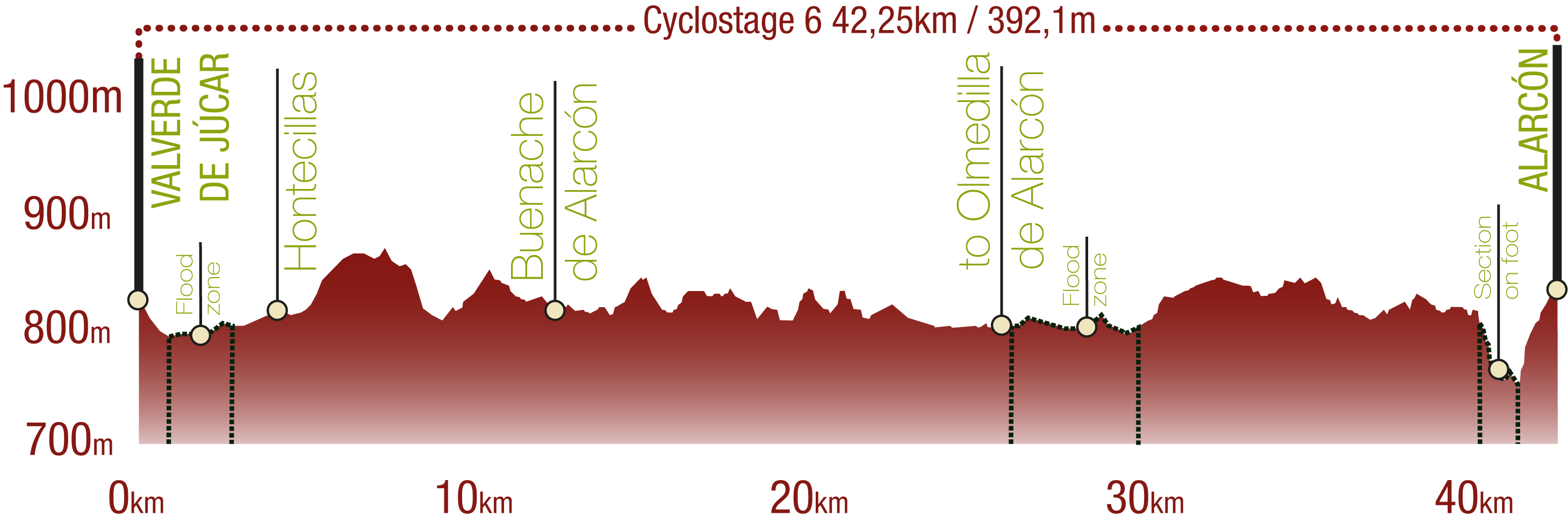
This Cyclostage corresponds to part of stage 10 and stage 11 of the Nature Trail
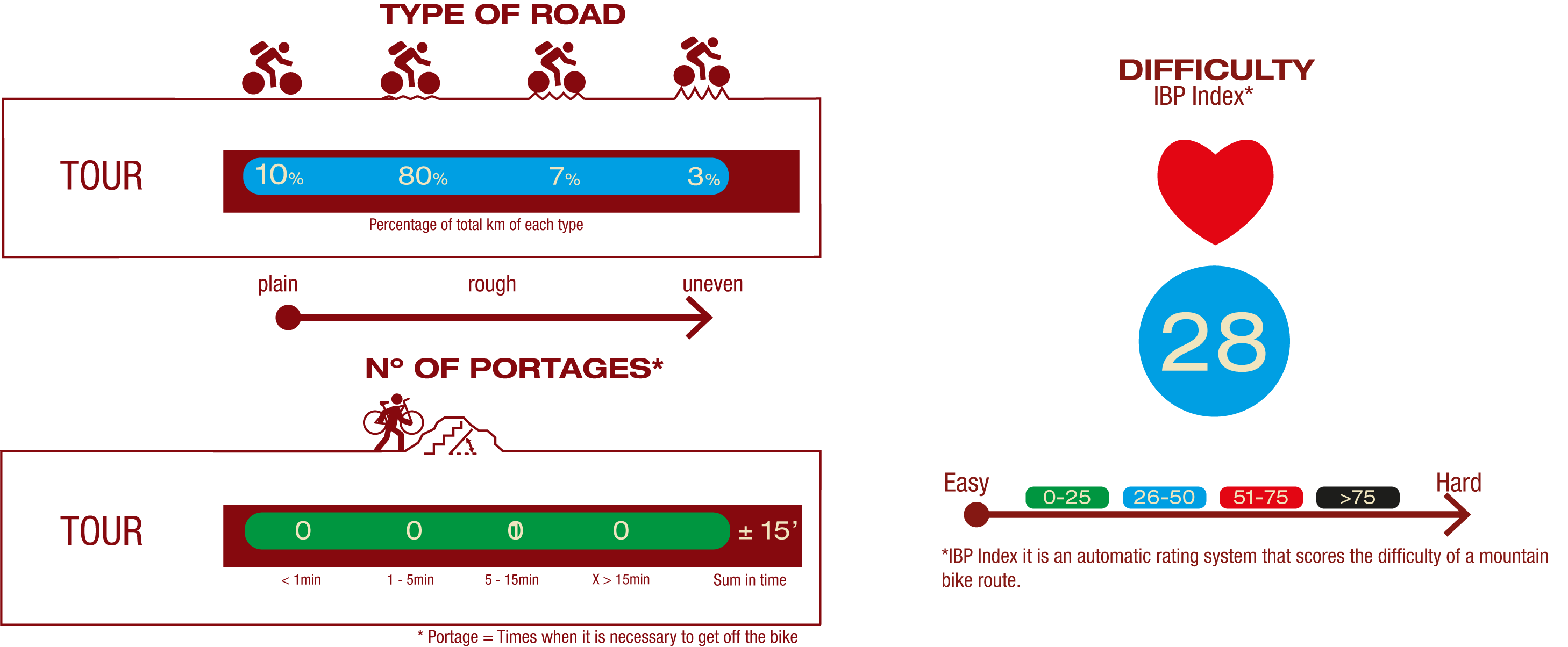
TYPE OF ROADS, PORTAGES & DIFFICULTY
SAFETY RECOMMENDATIONS
- The roads are mainly on tracks with access to farms and rural establishments, so there is a certain risk of being run over.
- There are two seasonal periods in which the Nature Trail is not passable if the waters of the Alarcón reservoir are very high. It is advisable to check this situation before setting off.
- Caution is advised at the junction of the CM-2100 and N-III roads.
- There is a walk of about 15 minutes along an uneven footpath with some risk of falls.
GENERAL RECOMMENDATIONS
- Find out about the technical aspects of the route and the weather on the day.
- Take care of the environment. Take care not to disturb animals or damage vegetation. Respect private areas.
- You must give priority to pedestrians and comply with general traffic rules.
- The environment in which you will be riding is open, free to move around and an area where many activities are carried out (sporting, forestry, livestock and agricultural activities). Always have an understanding, prudent, responsible and respectful attitude.


