


Net of Nature
Trails

Stage 0: Estación El Espinar-El Espinar







Description
This journey starts at the foot of the majestic Sierra de Guadarrama.
From the neighbourhood of Estación de El Espinar, the trail follows the course of the Gudillos river, allowing to enjoy the riverside woodland with its rock roses and Pyrinean oaks. After the spot called Colada de la Soledad, the shepherding tradition of the area becomes evident. In fact, the road taken to access the town of El Espinar by the shrine of the same name is a cattle road.
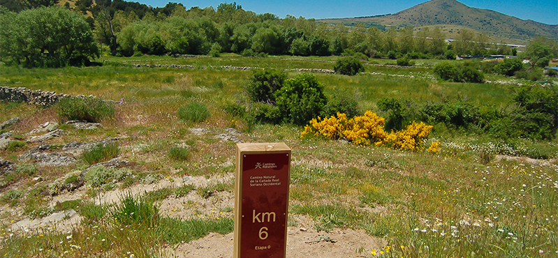
The Cañada Real Soriana Occidental Nature Trail starts in this "zero stage" which runs between the El Espinar Estación and El Espinar, which are almost 7 km apart.

The traveller starts their journey at the El Espinar train station, which is fully operative. The trail runs up a mild slope of an asphalted road, with the railway tracks to the left and the suburban area near the station to the right. Shortly afterwards, the road turns right and at the same time the suburban area ends and the asphalt road becomes a dirt road.
The route continues a wide dirt road until reaching kilometre point 1, a landscape where the gum rock rose (Cistus ladanifer) is the dominant species. As the trail runs down to the Puente del Rey bridge, this species is gradually replaced by Pyrenean oaks (Quercus pirenaica). After crossing this bridge, the trail turns right and runs along riverside woodlands by the River Gudillos.

Shortly after passing kilometre point 2, the path crosses below the N-603 and AP-61 roads and afterwards widens and runs by the river. When the trail reaches kilometre point 3, it turns away from the River Gudillos at the wastewater treatment plant of El Espinar, and shortly afterwards crosses the AP-6 road by the subterranean pass.
At kilometre point 4, the climb that started at the wastewater treatment plant end. The trail continues crossing pastures where cattle graze and, at kilometre point 5, crosses the La Pinilla creek.
After leaving behind the subterranean pass under the N-VI road and kilometre point 6 among nests of white storks, and the trails crosses the Soledad creek, named after the nearby shrine.

The traveller enters the town of El Espinar, crossing the road at the zebra crossing, and shortly afterwards reaches the aforementioned shrine of La Soledad. The trail continues by the street called Cañada Mari García until reaching a recreational area with a children's play areas, sport courts and activity circuit for the elderly.
At the monument that pays homage to all victims of terrorism the road turns right by a dirt path, and immediately afterwards the first interpretation panel can be found, indicating the end of this stage zero of this Cañada Real Soriana Occidental Nature Trails between Estación El Espinar and the town of El Espinar.
Sites of interest
Puntos de interés
Culture
Hydrography
Information
Infrastructure
Municipality
Orography
Hostel
Profile
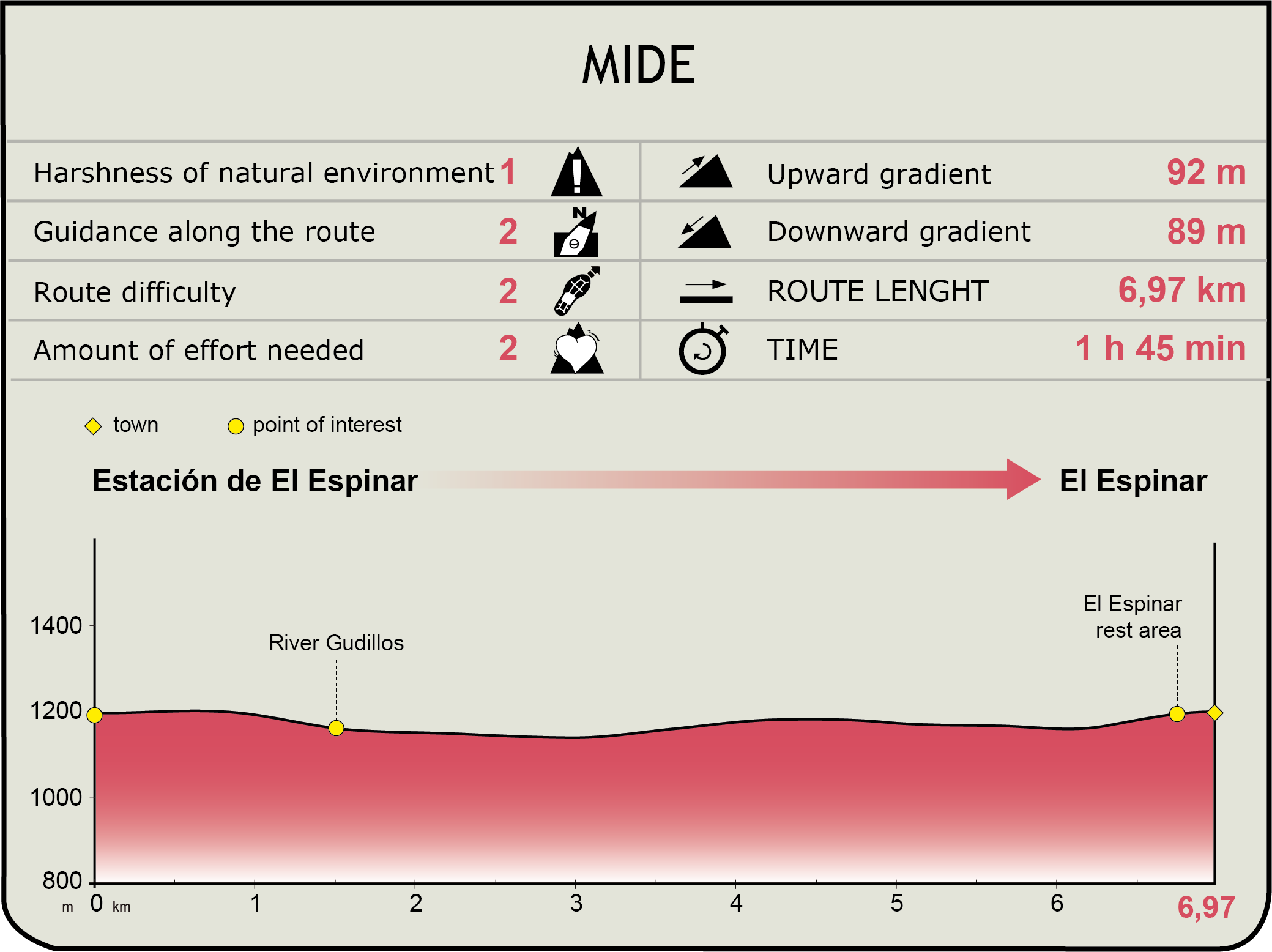
 Harshness of natural environment
- 1. The environment is not risk-free
- 2. There are more than one risk factors
- 3. There are various risk factors
- 4. There are quite a lot of risk factors
- 5. There are many risk factors
 Guidance along the route
- 1. Well defined trails and crossings
- 2. There is a clearly marked trail and signage
- 3. Requires the identification of geographic features and cardinal points
- 4. Requires off-path navigation
- 5. The trail is interrupted by obstacles that have to be gone around
 Route difficulty
- 1. Walking on a flat surface
- 2. Trails with different types of path
- 3. Walking on stepped paths or irregular terrain
- 4. The use of hands or jumping over the terrain is necessary
- 5. The use of hands is required to progress
 Amount of effort needed
- 1. Up to 1 hour of continuous walking
- 2. Between 1 and 3 hours of continuous walking
- 3. Between 3 and 6 hours of continuous walking
- 4. Between 6 and 10 hours of actual walking
- 5. More than 10 hours of continuous walking
(Calculated according to the MIDE criteria for an average excursionist with a light load)</
Highlights
El Espinar
A municipality in the province of Segovia formed by six separate villages: El Espinar, Gudillos, Prados, San Rafael, Los Ángeles de San Rafael and Estación El Espinar.
The first settlements in the area date back to the Roman era and remains have been found in the area known as Caloco. After the Visigothic and Arab rules, three separate municipal charters were used to re-populate the area after it was reconquered by the Christians. Forestal resources and intense livestock activities were the economic drives of the area for centuries. At the end of the 19th century the railways arrived, and a new village arose around the new train station, the village known as Estación El Espinar. Nowadays, tourism is the main economic drive, but many other activities wealth-creating activities are developed.
It boast a rich architectural and cultural heritage, among which the San Eutropio chirch in El Espinar and the Cristo de Caloco shrine in the hill of Caloco are specially noteworthy. The pilgirmage to this shrine acquired the National Tourist Interest status in 1977. Its location, at the foot of the Sierra de Guadarrama, and its climate favour the presence of a extremely wide variety of species of fauna and flora, some of them protected, which turn this municipality in an important site of environmental value
Multimedia


Downloads

GPS Downloads


Documents

Cyclability
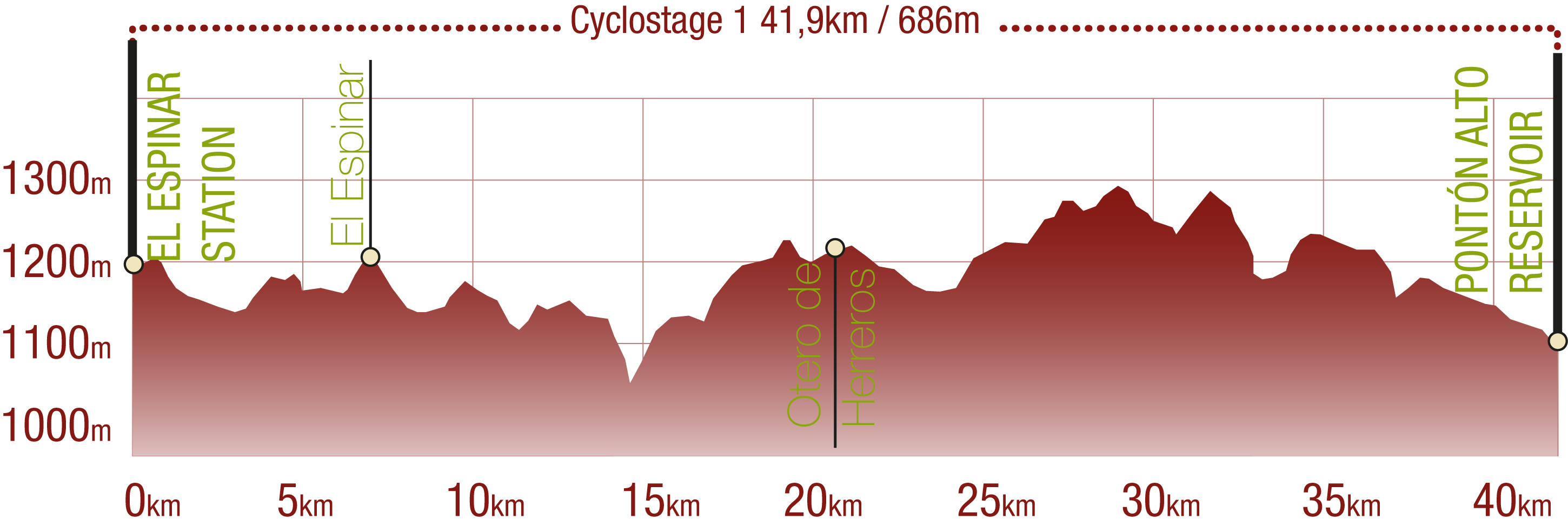
This Cyclostage corresponds to stages 0, 1 & 2 of the Nature Trail
PROFILE
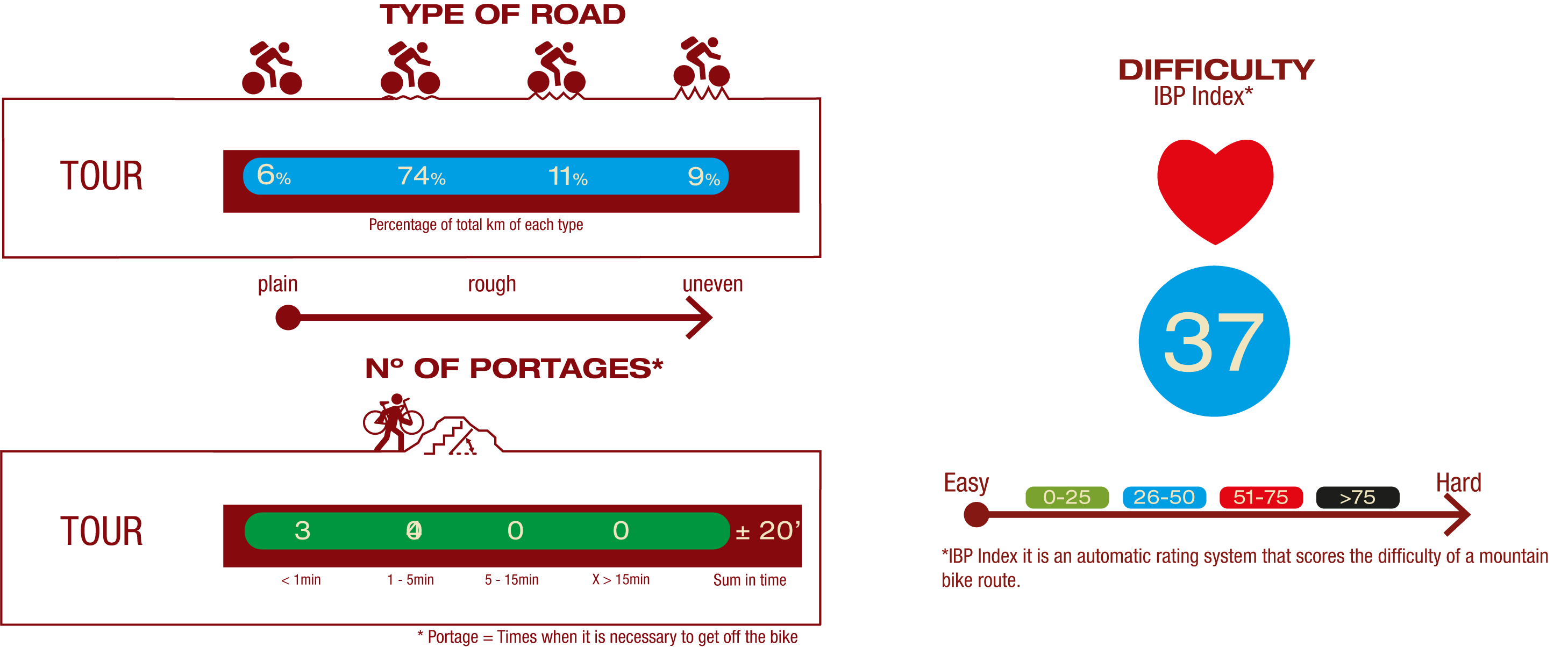
TYPE OF ROAD, PORTAGES & DIFFICULTY
TEST

SAFETY RECOMMENDATIONS
- Sections shared with hikers.
- Transit through the centre of some population centres.
- The Nature Trail presents, in stage 3, the crossing of a paved road across a solid line. Although there is enough visibility, extreme caution, and crossing dismounted, is advised.
GENERAL RECOMMENDATIONS
- Find out about the technical aspects of the route and the weather on the day.
- Take care of the environment. Take care not to disturb animals or damage vegetation. Respect private areas.
- You must give priority to pedestrians and comply with general traffic rules.
- The environment in which you will be riding is open, free to move around and an area where many activities are carried out (sporting, forestry, livestock and agricultural activities). Always have an understanding, prudent, responsible and respectful attitude.