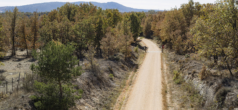
Camino Natural del a Cañada Real Soriana Occidental. Etapa 5: Navafría - Arcones

Net of Natural
Trails

Stage 5: Navafría – Arcones

Description

This stage provides the chance to enjoy the Sierra de Guadarrama Natural Park.

The traveller may start by swimming in the cool waters of river Cega in the natural pool of Navafría before taking a stroll through the streets of the town. Back to the pastures that are characteristic of cattle roads, many creeks streams run at the sides of the road. Especially noteworthy is the Riscos bridge over the river Pozas. The traditional resting areas called Descansadero de Gallegos and Descansadero Corral de la Mesta evidence the nearness of shearing houses in the area and are the most important heritage in this fifth stage along the Cañada Real Soriana Occidental drover's way, which ends at the municipality of Arcones, specifically in the village of La Mata.

Punto kilométrico 75 del Camino Natural de la Cañada Real Soriana Occidental

Stage 5 of the Cañada Real Soriana Occidental Nature Trail starts by the natural pool located in the pool of Navafría. It starts properly in the information panel which stands nearby and enters the pretty town of Navafría by the Calle de los Molinos. It runs along the whole length of this street until reaching the Plaza de Mayo, just facing the town hall.

Once the town hall has been reached, the trail continues right by the Calle de Mayo, which goes up to the left and leaves gradually the town by the road SG-V-6112, where the last houses are left behind. Shortly afterwards, the trail turns left and becomes a wide dirt path which runs among ash trees, an evidence of the humid nature of the soil.

Arroyo del Riacillo

Kilometre point 72 is reached and shortly afterwards the trail leaves to its right the town cemetery, before going uphill. The trail crosses the road SG-612 (please proceed with utmost care) and continues along the Cañada Real Soriana Occidental drover's way by the path to the right.

After reaching a new kilometre point, the road goes quickly downhill, leading the traveller to cross the river Pozas by the bridge known as Riscos bridge. Just afterwards, a steep slope makes the trail leave the valley behind and brings it back to its original height.

At this stage, the Cañada Real Soriana Occidental drover's way is enclosed by traditional stone walls which separate neighbouring states. Inside these states beautiful specimens of ash trees(Fraxinus angustifolia) and Pyrenean oaks (Quercus pirenaica) may be admired.

Melojo (Quercus pyrenaica) trasmochado

The environmental value of this stage is unquestionable, since it entirely runs by the Sierra Norte de Guadarrama Natural Park, which as also been included in the Natura 200 network as Specially Protected Area (SPA).

Kilometre point 75 is reached, with the heights of Sierra de Guadarrama looming always to the right. Shortly afterwards, the trail crosses a small creek by means of a ford placed for that purpose and a gate with a revolving door for walkers. The trail winds uphill and downhill along a short section in the small valley of the Riacillo creek and its tributary streams.

The trail continues along a wide, well-defined path. The trail turns right at the following crossroad, as signalled by the Nature Trail signals. Then, it goes uphill, leaving behind the Tollas creek, which is also a tributary of the aforementioned Riacillo creek.

Panorámica de Matabuena

After kilometre point 77, the trail turns left, leaves the dirt path and, without ever leaving the Cañada Real Soriana Occidental drover's way, reaches the traditional resting area called Descansadero de Gallegos. At this point, the Cañada Real Soriana Occidental exceeds its legally established width of 75 m so that its function as a resting space is guaranteed.

Shortly afterwards the trail reaches another traditional resting area known as Descansadero Corral de la Mesta, where lost or unidentified sheep and those used for paying taxes were kept, before a new gate with revolving door for pedestrians which acts a as border between the municipalities of Gallegos y Matabuena.

A succession of small creeks is crossed by means of fords. The largest of those creeks is the Guijar de las Ganchas creek. The trail runs constantly across pastures dotted with Pyrenean oaks whose branches were trimmed in the past to be used to feed the sheep when grass was scarce.

Señalización preventiva de pendiente pronunciada

The trail turns left by the wide dirt path, and abandons it a few metres afterwards by turning again, right this time, to continue this journey to the past by the Cañada Real Soriana Occidental drover's way. At this point, the traveller can see the town of Matabuena to their left. Shortly afterwards, the trail goes uphill and downhill crossing small temporary creeks by means of fords.

Kilometre point 80 is preceded by a new ford and, after crossing several creeks, the most noteworthy of which is the Palancar creek, and reaching a new kilometre point, the trail becomes a steep downhill slope; those travelling by bicycle are advised to get off their bikes and walk this section. The trail zigzags down the slope following the path in order to avoid walking in a straight line, which would be steeper. After crossing two fords the trail goes briefly uphill until reaching a gate with a revolving door for walkers. At this point, the tracing turns north and a downhill section begins where patches of Scots pines (Pinus sylvestris) are dominant, together with a diverse bush layer.

Ermita de Ntra. Sra. de la Lastra

Shortly before kilometre point 83, the trail reaches a crossroads and continues by the path at their left, which is a wide path crossing an area where pastures, mainly, and some cereal crops, become dominant instead of tree patches.

Before kilometre point 84 the road turns left with the sole purpose of reaching the municipality of Arcones, specifically the village of La Mata. The dirt path ends shortly after leaving behind the first houses, and at that point the trial turns right by the asphalt road called Calle La Mata. Walking along this road allows for visiting most of this small village. The asphalt road becomes a dirt path again as soon as the last houses are left behind, and on this dirt path the information panel signalling the end of this fifth road of the Cañada Real Soriana Occidental Nature trail between Navafría and Arcones can be found.

Mapa

Profile

MIDE Etapa 5
(Calculated according to the MIDE criteria for an average excursionist with a light load)

Highlights

Further information

Arcones

A municipality in the province of Segovia formed by five separate neighbourhoods: Castillejo, La Mata, Arconcillos, Coladillo and Huerta. Although there were Celtic settlements in the area, these where not permanent, due to the transhumant nature of livestock farming activities in the area. Being on the Cañada Real Soriana Occidental drover's way has has an impact on the development of the town, for, in the times where La Mesta, an association of transhumant sheep farmers dating back to the Middle Ages, was an active, lively institution, many people worked on trades related to livestock farming. Its architectural heritage boasts mainly religious buildings, among which the Romanesque San Miguel Arcángel church dating from the 13th century, and the shrine dedicated to Nuestra Señora de la Lastra, patroness of the town, stand out. The festivities in her honours are held on the second weekend of September.

Gallegos, Flagship of the Mesta

A municipality on Sierra de Pedraza located at an altitude of 1,242 m, making it the third highest municipality of Segovia after Riofrio de Riaza and El Muyo. The territorial scope of the municipality, from south to north, includes from La Muela and the high mountain pass of La Linera, to the footslopes close to Pedraza. This mountain pass, which is a though climb, communicates Gallegos with the Lozoya valley in Madrid. It seems that it takes its name from the fact that it was a trading station to export south the linen produced in the municipality and in nearby towns such as Torreval de San Pedro. Approximately in its middle, the municipality is crossed by the Cañada Real Soriana Occidental drover's way, which crossed the Peña Negra creek by the Ladrones bridge.

The town draws its name from the origin of its first settlers, which arrived to Castilian territories located beyond the Douro river in mid-13th century, under the rule of Alfonso VII the Emperor.

Multimedia

Cyclability

This Cyclostage corresponds to stages 3, 4 & 5 of the Nature Trail

PROFILE

TYPE OF ROAD, PORTAGES & DIFFICULTY

TEST

SAFETY RECOMMENDATIONS

- Sections shared with hikers.

- Transit through the centre of some population centres.

- The Nature Trail presents, in stage 3, the crossing of a paved road across a solid line. Although there is enough visibility, extreme caution, and crossing dismounted, is advised.

GENERAL RECOMMENDATIONS

- Find out about the technical aspects of the route and the weather on the day.

- Take care of the environment. Take care not to disturb animals or damage vegetation. Respect private areas.

- You must give priority to pedestrians and comply with general traffic rules.

- The environment in which you will be riding is open, free to move around and an area where many activities are carried out (sporting, forestry, livestock and agricultural activities). Always have an understanding, prudent, responsible and respectful attitude.

Introducción general al uso de cookies en MAPA.gob.es

Las cookies son archivos que se pueden descargar en su equipo a través de las páginas web. Son herramientas que tienen un papel esencial para la prestación de numerosos servicios de la sociedad de la información. Entre otros, permiten a una página web almacenar y recuperar información sobre los hábitos de navegación de un usuario o de su equipo y, dependiendo de la información obtenida, se pueden utilizar para reconocer al usuario y mejorar el servicio ofrecido.

Tipos de cookies

Según quien sea la entidad que gestione el dominio desde donde se envían las cookies y trate los datos que se obtengan se pueden distinguir dos tipos: cookies propias y cookies de terceros.

Existe también una segunda clasificación según el plazo de tiempo que permanecen almacenadas en el navegador del cliente, pudiendo tratarse de cookies de sesión o cookies persistentes.

Por último, existe otra clasificación con cinco tipos de cookies según la finalidad para la que se traten los datos obtenidos: cookies técnicas, cookies de personalización, cookies de análisis, cookies publicitarias y cookies de publicidad comportamental.

Para más información a este respecto puede consultar la Guía sobre el uso de las cookies de la Agencia Española de Protección de Datos.

Cookies utilizadas en la web

El portal web del Ministerio de Agricultura, Pesca y Alimentación utiliza Google Analytics, esta es una herramienta de analítica que ayuda a los sitios web y a los propietarios de aplicaciones a entender el modo en que sus visitantes interactúan con sus propiedades. Se utilizan un conjunto de cookies para recopilar información e informar de las estadísticas de uso de los sitios web sin identificar personalmente a los visitantes de Google. Más información sobre las cookies de Google Analytics e información sobre la privacidad. Estas cookies se pueden rechazar o aceptar ya que no interfieren en el funcionamiento de la página web pero sirven de gran ayuda aportando información que posibilita un mejor y más apropiado servicio por parte de este portal.

Por último, se descarga una cookie de tipo técnico denominada cookie-compliance, propia, de tipo técnico y de sesión. Gestiona el consentimiento del usuario ante el uso de las cookies en la página web, con el objeto de recordar aquellos usuarios que las han aceptado y aquellos que no, de modo que a los primeros no se les muestre información en la parte superior de la página al respecto. Esta cookie es de obligada utilización para el funcionamiento correcto del portal.

Aceptación / Rechazo de la Política de cookies

El Ministerio de Agricultura, Pesca y Alimentación permite la aceptación o rechazo de las cookies no esenciales para el funcionamiento del portal. Para ello una vez que el usuario acceda al portal se mostrará un mensaje en la parte central con información de la política de cookies y las siguientes opciones:

  • Aceptar cookies: Si el usuario pulsa este botón, se aceptarán los cookies no obligatorias y no se volverá a visualizar este aviso al acceder a cualquier página del portal.
  • Configurar cookies: Si el usuario pulsa sobre el botón de configurar, se accederá a una segunda ventana modal donde se podrá configurar que cookies aceptar. Esta segunda ventana explica las cookies utilizadas en la actualidad y permite la selección o rechazo de las cookies no obligatorias. Una vez finalizada la selección se deberá presionar al botón Guardar configuración.

Cómo modificar la configuración de las cookies

Usted puede restringir, bloquear o borrar las cookies del Ministerio de Agricultura, Pesca y Alimentación o cualquier otra página web, utilizando su navegador. En cada navegador la operativa es diferente, la función de "Ayuda" le mostrará cómo hacerlo.